21 Day Trip
Average Reviews0
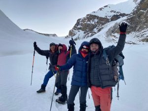
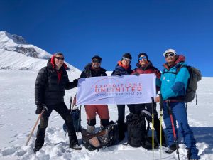
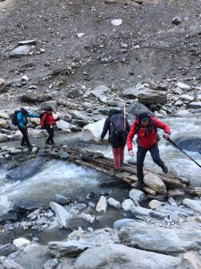
THAPA PEAK(6070M)
Thapa Peak, trekking peak exceeding 6000 m without much technical difficulty
- Duration 21 Days
- Includes Equipment, Drinks, Accommodations, Food
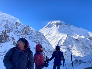
Dhaulagiri is the seventh highest mountain in the world at 8,167 meters (26,795 ft) above sea level, and the highest mountain within the borders of a single country (Nepal). It was first climbed on 13 May 1960 by a Swiss/Austrian/Nepali expedition. It is a difficult and challenging trek in an isolated region so trekkers must be in good physical condition and well equipped. From the French pass, the view of the almost perfect pyramid of Dhaulagiri (the White Mountain in Sanskrit) is grandiose. This trek which climbs all the stages of the vegetation to arrive on glaciers and moraines, is one of the very rare to pass as close to a summit of 8000m. It is also much uncroweded and wilders.
Located in the heart of the Dhaulagiri region, Thapa (Dhampus) Peak is an interesting destination.
The ascent to the summit starts on a gentle slope near the pass of the same name. Although the mountain exceeds 6000 m, there is no technical difficulty to climb. The trek goes through big challenging mountain passes, crossing over French pass (5,360 meter) and Thapa Pass (5,200 meter) providing more spectacular views of Dhaulagiri, Thorong peak, Annapurna Ranges and Kali Gandaki River; the world deepest gorge. Trekker walk through cultivated fields connected in the lower parts and to some of the mountain villages while enjoying the shops, teahouses, and lifestyle of the Gurung, Chhetri, and Magar people.
Trek Facts:
| >> Old-fashioned trek in bivouac and in autonomy |
| >> At the foot of the White Mountain |
| >> The most committed, isolated and wild towers of peaks over 8000m, and the hidden valley, true Shangri-La sheltered between 2 high passes to more than |
| >> 5000 m |
| >> Thapa Peak, trekking peak exceeding 6000 m without much technical difficulty |
| >> Views of Dhaulagiri from all angles, terraced valleys at the foot of glaciers |
After breakfast in the hotel we take a bus to the domestic terminal of Kathmandu Airport for the 45 minute flight to Pokhara. Here we board our transport for the 3 – 4 hour journey through a fascinating and lush landscape of emerald green rice paddies and dense forest on the steeper and higher slopes. Travelling deeper into the Annapurna Himal, we follow the Kali Gandaki river to the town of Beni and then follow its tributary, the Myagdi Khola, passing several small settlements, to arrive at the small rural town of Darbang where we make our first camp. Approximate altitude of camp is 1100 metres.
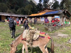
The trail continues along the Myagdi Khola passing through several villages before reaching Darbang where we stop for lunch. After we cross the suspension bridge and soon after start the climb to Dharapani. This village is mainly Gurung and chettri and has our first view of Dhaulagiri to the north. Overnight camping.
From Muri we descend steeply to the bridge crossing over the Muri Khola. After passing through dense bamboo stands the trail enters a number of clearings with fields and farmhouses. Further north the valley steepens and the trail is exposed in places. We camp in the grounds of the primary school in this village. Overnight camping.
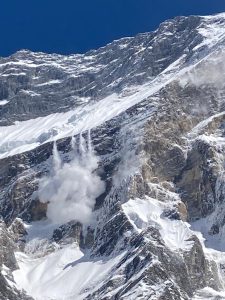
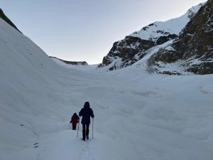
From Sallighari we walk through pine trees, rhododendron and birch and once above the tree line heather, juniper and azaleas. The trail traverses through forest and then climbs to a grassy area on the lateral moraine where Italian Base Camp is located. High above camp is the impressive west face of Dhaulagiri with Tsaurabong Peak visible on the other side of the valley. Overnight camping.
Today we can go for a walk to explore around Italian Base Camp or relax in camp. This day is essential for acclimatization before ascending further in altitude towards main Dhaulagiri Base Camp. Overnight camping.
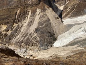
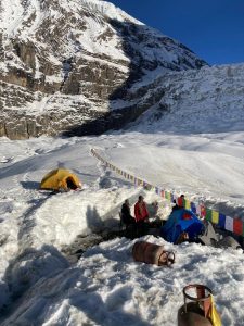
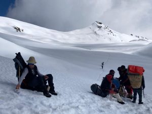
Today is a shorter walk although essential for acclimatization process unlike most other itineraries we believe in having two nights at Glacier Camp located between Italian Base Camp and main Dhaulagiri Base Camp (otherwise going from 3,660m to 4,740m will result in altitude sickness). From Italian Base Camp the trail descends steeply down lateral moraine to gain the glacier, in the past we have fixed a rope here to help the group and trek crew. We cross the glacier and then traverse along the moraine on the left side of the Chonbarden gorge. We walk along talus in the impressively narrow Chonbarden gorge to the snout of the Chonbarden glacier and then continue for another hour to Glacier camp. There are a number of ledges leveled in the ice of the glacier for our tents. Overnight camping.
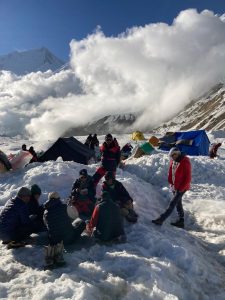
We follow a rough trail along the moraine covered glacier to Dhaulagiri Base Camp. From Base Camp the view is impressive with Dhaulagiri I, Tukuche Peak and Little Eiger and further to the west lays Dhaulagiri II (7,751m) and IV (7,618m). One can also see the start of the climbing route through the icefall. In season there are likely to be expeditions camped on the moraine strip at Base Camp. Overnight camping.
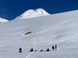
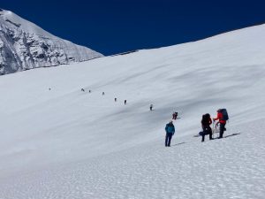
After an early breakfast we walk out of Base Camp along the moraine strip to cross over to the left hand side of the Upper Chonbarden glacier. A high lateral moraine ridge is visible further up the valley; we gain this by following a steep trail across the screen and talus. Once on the lateral moraine ridge there are superb views back down the valley to Dhaulagiri I and Tukuche Peak. At a large cairn on the lateral moraine ridge we turn off to make the final ascent to French pass .The approach to the pass is up easy angled snow slopes and as usual in Nepal the top is marked by Buddhist prayer flags and cairns. The view from the summit of the pass is superb with Sita Chuchura, the peaks of the Mukut Himal, Tashi Kang, Tukuche Peak and of course Dhaulagiri I. The descent from pass is on moderate snow slopes as we enter Hidden Valley. After a long descent you arrive to camp next to the river not far from the base of Dhampus Peak. You will notice once crossing into Hidden Valley there is only sparse vegetation of isolated patches of moss and grass as this area is now in an area affected by the rain shadow effect of Dhaulagiri. Overnight camping.
This is a long day and by far the toughest on Dhaulagiri Circuit trek. After an early start from camp we start the climb up a moderate snow slope to gain Dhampus pass. There are fine views of Dhampus Peak to the left of the pass and to the right the beautiful ice flutings of Tukuche Peak. From the summit of the pass the trail descend pass for about 100m before start to traverse left into Kali Gandaki valley. Depending on the snow and ice conditions crampons may be needed for group & porters at this point. There is a very long traverse on snow usually taking about four hours before starting the steep descent to Yak Kharka. Throughout this traverse there are stunning views of Nilgiri and the western end of the Annapurna Massif. Overnight camping.
There is a very long traverse on snow usually taking about five hours before starting the steep descent to Yak Kharka. Throughout this traverse there are stunning views of Nilgiri and the western end of the Annapurna Massif. Overnight camping.
There is a long descent today to the village of Marpha located in the Kali Gandaki valley. Marpha village has a Buddhist monastery, Tibetan whitewashed houses and paved streets. It is also famous for its apple orchards so well worth stopping here to get a glass of apple juice at one of the lodges. In Jomsom is the best place in town located opposite the airport. After hot showers you can explore Jomsom, check emails then in the evening the cooks will produce a special last meal together. Later on we will hand out tips to our crew as a thank you for all their hard work throughout the trek. Overnight: teahouse lodge.
Cost Include
Cost Non-Includes